Summer Migration North
Okay, we've been enjoying our travels way too much, and as a result our blog is lagging by a few too many months. So time to start catching up...
 |
| Homer Smith is a great marina, and often has fresh off-of-the boat shrimp. Yum! |
As the heat and humidity increases in late May, we are still at the dock in Homer Smith Marina in Beaufort North Carolina. Our thoughts and plans are quickly turning to the cooler climate of Maine. Because of the constantly changing Covid 19 restrictions, that vary wildly from state to state, we are plotting a route that will get us to Maine with the fewest number of stops, and little reason to go ashore.
We plan to leave at first light, but our dock neighbors suggest a later start because 150 sports fisherman boats in the "Big Rock Blue Marlin Fishing Tournament" will roar out of the harbor at the time we want to leave. Since we cruise at 8 knots, and they go 22+ knots, we will let them go ahead of us! Similar to the start of the New York Marathon… the fastest runners get to start first!
 |
| I never understood why you have to go super fast to go fish!? |
Later in the day, as we are cruising off the coast of Cape Hatteras, we can see a pack of these boats returning to Morehead City to have their catches weighed.
 |
| Bravo is the red boat, and pretty soon we were surrounded by sport fishing boats. |
This year the prize-winning marlin in this tournament was in excess of 495 pounds! Michael Jordan also participated with his 80' Viking sport fishing boat named "Catch 23", and they caught a 442 pound blue marlin. But it wasn't big enough to be on the leader board.
 |
| These fish are seriously big! But this was not a prize winner at a mere 415 pounds! |
Offshore Run
The first segment of the cruise plan is a non-stop three-day offshore run from Beaufort, North Carolina to the entrance of the Cape Cod Canal, Massachusetts. To minimize travel time, this route takes us about 100 miles offshore. Initially, seas are calm, and every now and then a pod of dolphins joins us for a bow wave ride.
 |
| These dolphins are great entertainment, and they're like the synchronized swimmers of the sea. |
Batten Down the Hatches
As the trip progresses, the weather deteriorates. Skies turn cloudy, seas are high, and it is a bit of a rough ride. Actually, the sea conditions became untenable. Waves were in excess of 8-10 feet and the period (time between waves) was very brief… probably 5 seconds or less. This combination caused the bow to rapidly rise and fall repeatedly slamming the boat into oncoming waves. You need to be extra careful as you walk or move around the inside of the boat in these conditions. Fortunately, our cruising philosophy is that everything on the boat, inside and out, is put away, locked down, or contained when underway. One experienced sail boater said, “if you turn the boat upside down, nothing should fall out”. Very good advice when you hit rough seas!
 |
| Yee Haw! |
After a few hours of this pounding, we decide to alter our course, get closer to shore and calmer seas. Much better ride.
Night Passage and Watch Schedules
Darkness falls and the first of several night watches begin. Typical watch schedules, with a four person crew, are 4 hours on and 12 hours off; with a three person crew, 4 hours on and 8 hours off. This rotation gives each crew member plenty of time for sleeping, eating and relaxing which keeps them alert “on watch”. To optimize this type of schedule rotation, many cruising couples will add 1-2 crew when doing a multi-day 24/7 offshore run.
Cruising couples like us, with just two people on a boat, typically do not have the luxury of long “off watch” night shifts as described above. Based on personal preferences and individual tolerance levels, the two-person crew invents different schemes for night watches. Some couples do long shifts dividing dark hours so each person gets a “full night’s sleep”. We have found that during a long (5-6 hour) night watch it is difficult for us to maintain a level of alertness necessary for safe operation of the boat. Therefore, our night watches alternate turns at the helm every 3-4 hours while the other person sleeps/naps. We supplement the short nights with more naps during the daylight hours.
Night Navigation
During your night watch, there are plenty of navigation/radar screens and gauges to monitor and keep you busy. Nighttime marine traffic this far offshore is usually large commercial ships and fishing vessels. Commercial ships display an AIS triangle-shaped icon and the name of the vessel on your navigation system’s computer screen. One or two clicks on the mouse produces information on type of boat, length, width, cargo, speed, course, distance from your boat, and destination. This feature is a tremendous supplement to visuals and radar for night navigation and provides you with information if you need to contact the other boat on the VHF radio. Many fishing boats have ultra-bright work-lights on their decks which make them easier to notice in the pitch dark. If they have AIS the fishing boats also appear as triangles on your navigation screen. However, some boats operate without AIS or additional lights. You learn to read “blips” on the radar to identify non-AIS boats in your vicinity.
 |
| Running at night onboard Bravo. |
Bravo also has an infrared camera system known as FLIR (Forward Looking InfraRed). In layman’s language this is a night vision camera. This camera is mounted on the top of the pilothouse and can be directionally adjusted, or zoomed in or out, remotely from inside. In the photo of the pilothouse “control panel”, the FLIR display is the red screen on the left-hand side of the photo. This tool is especially helpful for night cruising in tight quarters such as a shipping channel with lots of other boats and navigation buoys, or in an anchorage.
Plan B - NYC to Long Island Sound
After three days and two nights cruising 24/7 bouncing around offshore, we were very happy to enter New York Harbor and anchor in Sandy Hook, New Jersey.
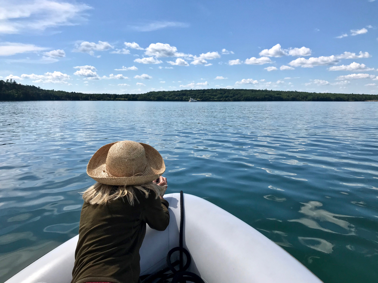
 |
| Nora's at the helm with her Schooner Zodiac shirt. The Zodiac is a wonderful schooner in Bellingham, WA. |
A bit short of our original goal of Cape Cod Canal, but the offshore conditions were too much “rock and roll” for our tastes. Tomorrow is the trip up the East River past Lower Manhattan and through Hell’s Gate to Long Island Sound.
New York, New York
We have now made four cruises through the heart of New York City. Each time it is one of our favorite sections of our north/south “migration”. Even though we both spent a lot of time growing up in and around New York, cruising the East River and New York Harbor is an amazing “once-in-a-lifetime” experience every time we do it.
This trip only takes 3 hours but requires thoughtful preplanning to ensure favorable tides and currents through Hell’s Gate. Ebb and Flood tide changes in the East River run with or against you at up to 5 knots! Bravo cruises at 8 knots, so we don’t want to crawl upstream against a 5 knot current. On the other hand, 5 knots pushing your stern is not helpful. That much power from behind compromises your directional control. With so many ferries, barges, and other commercial boats operating in tight quarters on the East River, you definitely must maintain directional control. Therefore, we time our transit to coincide with slack tide.
 |
| You really need to be fully engaged as you navigate your way through the waterways of New York City. |
The night before the trip, Nora enters a detailed course from Sandy Hook to Port Washington, New York into Bravo’s navigation system. This track helps us stay on-course following many red and green buoys and prevents any wrong turns. The harbor and river contain many side channels and there are no signs mid-stream saying, “Long Island, Next Left Turn”.
In spite of these challenges, any boater who has the opportunity to cruise New York Harbor, we highly recommend you do it!
Ships of all Sizes and Shapes
The day of our trip dawns bright, clear, and sunny! New York Harbor is still one of the busiest ports in the world. Aboard Bravo, we share this waterway with an incredible variety of marine vessels… anchored and underway. Nora’s at the helm, Karl is photographing the trip and helping with navigation. Sharp eyes watching 360, and sharp ears listening to the VHF radio channels are required at all times.
The upper bay is a marine parking lot! Some boats are anchored, and others are connected to huge mooring buoys.
 |
| These barges are anchored as they await their turn to offload their cargo. |
The iconic orange Staten Island Ferry departs its lower Manhattan Terminal and dashes across the bay.
 |
| The six large bays are the Staten Island Ferry Terminal. |
 |
| We see quite a few of the Staten Island Ferries, and we steer well clear. |
The harbor and rivers are similar to a major interstate highway with all sorts of boats traveling in all directions. Dodging a plethora of vessels is the work of the day.
 |
| It's amazing how many containers are loaded onto these ships! |
 |
| Fireboat passing under the Brooklyn Bridge. |
We also see a ship that could possibly be a “stretch Nordhavn 62”… and a ship that did not make it out of New York!
 |
| This is the profile of a 62' Nordhavn. |
 |
| This looks like a Nordhavn 62, with an additional hundred feet or so. |
 |
| In typical New York City fashion, there's even graffiti on the bow of this rust bucket. |
Landmarks and Landscapes
But our eyes are not just on the water. The shoreline is a continuous display of monuments, architecture, and iconic NYC urban landscapes.
A tiny lighthouse warns boats of shallow water on the New Jersey side of the Hudson River.
 |
| Every lighthouse we see is unique, and has a lot of character! |
The Stature of Liberty, Jersey City, and Lower Manhattan are a jaw-dropping panorama. New Jersey is on the left and NYC is on the right.
 |
| It's really an awesome & memorable sight to come into NYC by water, and to be greeted by the Statue of Liberty! |
 |
| The Statue of Liberty was definitely positioned to welcome boats as they arrived to New York City. |
Just north of Liberty Island in the Hudson River is Ellis Island. Thousands of immigrants caught their first glimpse of America from these waters. Between Ellis Island’s opening in 1892, through its closing in 1954, nearly 12 million immigrants passed through this gateway to America. After the facility was closed, it fell into disrepair.
In the mid-1970’s we were art majors at Montclair State University, and our photography professor, Klaus Schnitzer, obtained permission to have his students photograph the buildings and grounds before restoration began. It was a unique opportunity to visit and document the island in its abandoned state. Empty rooms, crumbling walls, battered suitcases, clothes, and personal belongings were silent reminders of the people who passed through seeking a better life. If you ever visit NYC, Ellis Island is a “must see”.
 |
When we photographed Ellis Island in the 70's it was abandoned, crumbling, and and overgrown.
Now, thankfully it's back to it's original glory. |
We steer away from Ellis Island and head west across the bay. The Lower Manhattan/Battery Park skyline includes the new “World Trade Center”.
 |
| We love the views of New York City from the water. |
Turning the corner and up the East River we pass close by the United Nations.
 |
| ...Really close! |
Bravo passes under eight bridges that span these waterways and continues upstream.
 |
| We pass under the Brooklyn Bridge and the Manhattan Bridge. |
As we leave the Manhattan skyline to our stern, a tiny lighthouse marks the western entrance to Long Island sound and our destination for the night, Port Washington, NY.
 |
| Before the lighthouses were automated, lighthouse keepers lived onsite to keep it running. |
Port Washington, NY
Normally, we stay 1-2 weeks in Port Washington to enjoy shops and restaurants, provision, and take the train into NYC to visit friends and see the sights. However, Covid creates a different world of masks and take-out food. This is a quick stop, with social distancing to provision and move on to less populated areas.
However, Port Washington is on our list of favorite and must stop at port of calls. The mooring buoys are such a super deal, and it includes the water taxi! The water taxi takes you right to the heart of this wonderful town, and the train to New York City leaves from this town if you wish to go explore the "Big Apple".
 |
| Port Washington is a boat friendly town that has so much to offer. |
 |
| The Port Washington water taxi brings us back to Bravo. |
Port Washington, NY to Block Island, RI
Summer brings 15-17 hours of daylight allowing us to making long cruises and still anchor before dark. We have a calm clear day to head east on Long Island Sound.
 |
| This was like cruising on a calm lake. |
After we pass through “The Race” (eastern end of Long Island Sound) the clear day turns foggy and we continue, with radar running, all the way to Block Island. Once again, we stop only for the night to avoid Covid restrictions onshore. We are sorry to miss the many sights and tasty delights of Block Island, but it’s a different world than our last visits in 2019.
Block Island to Cape Cod Canal and Massachusetts
The next morning dawns bright and clear as we depart Block Island.
 |
| We exit the narrow channel that leads to what is known as the "Great Salt Pond" anchorage in Block Island. |
 |
| Onward and outward into the waters of Rhode Island Sound. |
 |
| The weather quickly changed. ...Again! |
Unfortunately, the clear day quickly turns foggy and we plod along to our anchorage just south of the Cape Cod Canal entrance. Not too much to look at. Just grey, grey, grey outside our windows. In the pilot house, watching radar and AIS for navigational aids and other boats also moving carefully around in the fog.
 |
| Foggy, foggy, foggy... |
Cape Cod Canal to Gloucester, MA
Here we go again… up early to catch a favorable tide/current through the Cape Cod Canal and then on to Gloucester, MA. The rising sun shines through the bridge as we pass the Massachusetts Maritime Academy located at the southern end of the canal. This marine-focused college is one of 6 state-sponsored maritime academies in the US… Others are located in Maine, New York, Michigan, Texas, and California.
This man-made sea level canal built in the early 1900’s has no locks. Connecting Cape Cod Bay in the north with Buzzards Bay in the south, the 7-mile waterway effectively separates Cape Cod from mainland Massachusetts. Taking this short cut saves about 135 miles for recreational and commercial ships.
Karl is at the helm. Only 1-2 other boats pass us during our hour long transit.
 |
| We're approaching the Sagamore Bridge in the Cape Cod Canal. |
Late afternoon we arrive in Gloucester, MA and we head to our favorite Gloucester anchor spot directly in front of a well known Nordhavn owners house!
Gloucester, MA to Kittery, ME
Same story… just a one night stop. No going ashore for sights, sounds, or shopping. The next morning we are up and out early. Clear skies and lobster pots greet us as we exit the harbor and head north. We know for sure, now we are in New England!
We make an easy day’s cruise to Pepperrall Cove in Kittery, Maine. Kittery is the southernmost stop in Maine across the Piscataqua River from Portsmouth, New Hampshire. A tiny lighthouse guards the entrance to the shared harbor. Drop the hook, eat, sleep, get up and go in the morning.
 |
And here we have an example of your classic lighthouse style.
|
Kittery, ME and onwards North to Summer Cruising Grounds
Early morning/sunrise departure brings blinding light directly in the front windshield of the pilothouse. We proceed carefully because the glare makes seeing lobster pots virtually impossible! Finally out of the harbor, we turn in a more northerly direction thus avoiding the glare.
 |
| Just looking at this picture has me reaching for my sunglasses! |
 |
| There are areas where the number of lobster buoys is insane, and we have to steer our way through! |
We anchor in Harpswell Harbor, ME. A few other local boats on mooring buoys keep us company. The reduced number of boats anchored out this summer is starting to become more obvious.
Lobstah, Lobstah, Lobstah!!!
The plethora of lobster buoys never ceases to amaze us, and we certainly appreciate the delicious outcome of all this hard work! We are always thrilled to arrive in Maine and enjoy lobster every week. Whenever in town, we seek a local source for fresh lobster and corn on the cob.
 |
| The only time it's cheaper is if we're able to buy right off of the lobster boat. |
Lobster, Homarus americanus, has been commercially fished in Maine since the mid-1800’s. 90% of US lobster currently comes from Maine. Last year, 4,500 Maine lobstermen caught 120 million pounds to be shipped and eaten all over the world! People eat lobster, but what do lobsters eat? Lobsters are nocturnal and hunt at night for crabs, sea stars, sea urchins, fish, clams, mussels, worms, and sometimes each other!! Lobsters are left or right-handed and have a heavy claw for crushing and a narrow claw for cutting. Lobstermen have a special tool to put a strong rubber band on each claw as soon as they are removed from the trap. It protects the lobsterman from the lobster and the lobsters from each other!
 |
| Lobster boats at the ready for the morning catch. |
 |
| We love the humor in the name, and check out that exhaust! |
 |
| This lobster boat was named "Bonnie's Brats". Glad we didn't meet the kids! |
Where ever we go, we talk to the locals and learn more and more about lobstering and its impact on life in Maine. Friends recommend books and websites to expand our knowledge and appreciation for lobster. Nora especially enjoyed, The Secret Life of Lobsters by Trevor Corson, telling the story of lobster fishing families on the Cranberry Islands. Our “home bases” in Rockland and Southwest Harbor put us in the epicenter of the Maine lobster industry providing easy access to Cranberry Islands, Isle Au Haut, Stonington, and Penobscot Bay.
 |
| We visited Little Cranberry Island, which was picturesque. |
Lobstering is second only to the timber industry in Maine. However, lobstering is many small family businesses with each boat typically carrying only a captain and a stern-man. Some captains fish alone, but that practice is considered very dangerous. Average income for a Maine lobsterman is $43,000. Overhead is high with traps costing about $100 each; bait is $30.00 a barrel (5-8 barrels a day); plus boat, fuel, and 20% to the stern-man. Boat and trap maintenance are formidable annual expenses. Fisherman estimate 15-20% of trap gear is lost every year due to boat traffic.
 |
| New lobster pots ready to go. |
 |
| Some slightly used lobster pots. |
Up to 800 traps are permitted with a commercial license. Licenses cost between $167-$501 plus .50 cents for each trap tag. To obtain a lobster fishing license, you must be a Maine resident, and the waiting list is nearly 10 years long. Non-commercial licenses for 5 traps are available for Maine residents beginning at 8 years old. Many a Maine youngster starts earning their way at an early age! Traps can be set at any time, but they can only be hauled between sunrise and sunset. Additionally, between June 1 and September 1, no traps can be hauled between sunset on Saturday, and sunrise on Monday. Buoys mark the set traps and the color scheme is unique to each lobsterman as noted on their license.
 |
| These buoys are old, but you can see the variety of color schemes. |
 |
| We saw this on a remote beach. Pretty cool! |
To help maintain this valuable resource, Maine has some of the most conservation-oriented lobstering regulations in the industry. Even though Maine lobster season is open 12 months a year, most of lobsters that show up in a trap are immediately released. Legal lobsters are only those measuring between 3¼-5 inches of body length and are not “V-notched” females. “V-notched” females are egg-carrying lobsters marked by the fisherman with a notch in their tail. They are always thrown back to continue producing more baby lobsters in the cold rocky Maine waters.
It takes 5-7 years for a lobster to reach 1.5 pounds and 15-20 years to become 3 pounds. To reach minimum size, lobsters shed their shells 20-25 times growing 20% larger each time they molt. Most of this molting or shedding occurs during the summer months. Therefore, soft-shell lobster is the variety available during tourist season. Hard shell lobster is typically available after October and before May.
If you would like to know more about Maine lobsters you can check out The Lobster Conservancy at lobsters.org, lobstermanpage.net, or lobsteranywhere.com, and another fun book, The Lobster Chronicles by Linda Greenlaw.
 |
| Doing our best to support the local lobster industry! Yum! |
Now that we are in Maine, we keep moving slowly north spending 1-2 days in secluded anchorages, just going ashore a couple of times for provisions and supplies.
 |
| Bravo at anchor. |
The weather is significantly cooler that what we left behind in the mid-Atlantic states and foggy days are part of the “Maine cruising experience”. Traveling in heavy fog is a disorienting and exhausting experience. There is no differentiation between sea and sky. No horizon. Visibility rapidly changes from 100 feet to 0 feet. The flat light and lack of detail eliminates any depth perception.
Lobster buoys and navigational buoys appear out of nowhere and float in sea of gray. It takes two persons to run the boat. One to watch the blank wall of fog for hazards, and one person to steer and navigate the course in-between numerous islands.
 |
| Even though cruising through the fog can be challenging, it does make for some great photo ops! |
Strange boats appear out of the fog and disappear a few moments later!
 |
| This bizarre looking boat appeared out of the fog. I can't imagine that there is more than one of these! |
Several days we are anchored or cruised in fog for the entire day.
 |
| The fog really changes the overall setting to feel kind of surreal or eerie. |
We are very happy to see fog burn off and enjoy a spectacular sunset.
 |
Ahh!
|
 |
| Time to relax and have a glass of wine. ...or two! |
As described in previous blog postings, quarantine and social distancing on a Nordhavn is easy. We are self-contained and typically anchor out…. Surrounded by water and lobster buoys! We don't need to stay in a hotel or eat in restaurants. By the time we complete our 14-day quarantine, we are in Penobscot Bay… cruisers paradise!
 |
| This says it all! |


Fantastic. A challenging trip on almost every front. But the payoff at the end: beautiful Maine and all the fresh lobster you can eat! Do you have a good source for white burgundy, though?
ReplyDeleteSuch fun to see all your photos of the trip north.
ReplyDeleteWe'd love to see you - or at least wave - as you transit the East River in NY. Keep us posted on your timeline and we'll see if we can connect.
If not, keep the photos coming. Always fun to see what you see.
Happy birthday to Nora. \
Safe travels.
S
Great to get an update from you two again and read of your cruisings!!
ReplyDeleteMakes me want to gate crash your party :) I feel like I’ve been missing out !
ReplyDeleteI Live Vicariously through You! Well Done! Beautiful Trip!
ReplyDeleteYou Rock ... Lobster! [https://youtu.be/d1Nq82S7_0Q]